|
Origins of the Compass Rose*

|
The compass rose has appeared on charts and maps since the 1300's when the portolan charts first made their appearance. The term "rose" comes from the figure's compass points resembling the petals of the well-known flower.
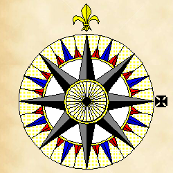
Originally, this device was used to indicate the directions of the winds (and it was then known as a wind rose), but the 32 points of the compass rose come from the directions of the eight major winds, the eight half-winds and the sixteen quarter-winds.
|
|
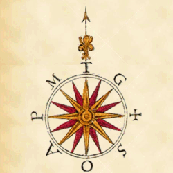
In the Middle Ages, the names of the winds were commonly known throughout the Mediterranean countries as tramontana† (N), greco (NE), levante (E), siroco (SE), ostro (S), libeccio (SW), ponente (W) and maestro (NW).
On portolan charts you can see the initials of these winds labeled around the edge as T, G, L, S, O, L, P, and M.
|
|
|
The 32 points are therefore simple bisections of the directions of the four winds (but the Chinese divided the compass into 12 major directions based on the signs of the Zodiac). For western apprentice seamen, one of the first things they had to know were the names of the points. Naming them all off perfectly was known as "boxing the compass"‡.
There is no absolute standard for drafting a compass rose, and each school of cartographers seems to have developed their own. In the earliest charts, north is indicated by a spearhead above the letter T (for tramontana). This symbol evolved into a fleur-de-lys around the time of Columbus, and was first seen on Portuguese maps. Also in the 14th century, the L (for levante) on the east side of the rose was replaced with a cross, indicating the direction to Paradise (long thought to be in the east), or at least to where Christ was born (in the Levant).
The colors on the figure are supposedly the result of the need for graphic clarity rather than a mere cartographical whim. On a rolling ship at night by the light of a flickering lamp, these figures had to be clearly visible. Therefore the eight principle points of the compass are usually shown on the compass rose in black which stands out easily. Against this background, the points representing the half-winds are typically colored in blue or green and since the quarter-wind points are the smallest, they are usually colored red.
|
|
|
The 32 Points of the Compass
|
| Point |
Direction |
Azimuth |
Wind |
|
Point |
Direction |
Azimuth |
Wind |
| 0 |
North |
0° - 0' |
tramontana |
|
16 |
South |
180° - 0' |
ostro |
| 1 |
N by E |
11° - 15' |
quarto di tramontana
verso greco
|
|
17 |
S by W |
191° - 15' |
quarto di ostro
verso libeccio
|
| 2 |
NNE |
22° - 30' |
greco-tramontana |
|
18 |
SSW |
202° - 30' |
osro-libeccio |
| 3 |
NE by N |
33° - 45' |
quarto di greco
verso tramontana
|
|
19 |
SW by S |
213° - 45' |
quarto di libeccio
verso ostro
|
| 4 |
NE |
45° - 0' |
greco |
|
20 |
SW |
225° - 0' |
libeccio |
| 5 |
NE by E |
56° - 15' |
quarto di greco
verso levante
|
|
21 |
SW by W |
236° - 15' |
quarto di libeccio
verso ponente
|
| 6 |
ENE |
67° - 30' |
greco-levante |
|
22 |
WSW |
247° - 30' |
ponente-libeccio |
| 7 |
E by N |
78° - 45' |
quarto di levante
verso greco
|
|
23 |
W by S |
258° - 45' |
quarto di ponente
verso libeccio
|
| 8 |
East |
90° - 0' |
levante |
|
24 |
West |
270° - 0' |
ponente |
| 9 |
E by S |
101° - 15' |
quarto di levante
verso siroco
|
|
25 |
W by N |
281° - 15' |
quarto di ponente
verso maestro
|
| 10 |
ESE |
112° - 30' |
levante-siroco |
|
26 |
WNW |
292° - 30' |
maestro-ponente |
| 11 |
SE by E |
123° - 45' |
quarto di siroco
verso levante
|
|
27 |
NW by W |
303° - 45' |
quarto di maestro
verso ponente
|
| 12 |
SE |
135° - 0' |
siroco |
|
28 |
NW |
315° - 0' |
maestro |
| 13 |
SE by S |
146° - 15' |
quarto di siroco
verso ostro
|
|
29 |
NW by N |
326° - 15' |
quarto di maestro
verso tramontana
|
| 14 |
SSE |
157° - 30' |
ostro-siroco |
|
30 |
NNW |
337° - 30' |
maestro-tramontana |
| 15 |
S by E |
168° - 45' |
quarto di ostro
verso siroco
|
|
31 |
N by W |
348° - 45' |
quarto di tramontana
verso maestro
|
Notes |
| * |
by Bill Thoen, GISNet, "Origins of the Compass Rose"
|
| † |
"‘Prodigious fine day,’ said Jack, gazing upon his rat-like visage with great benevolence. ‘Bello soleil, indeed. But,’ he added, bending down and peering out of the upper part of the window, ‘it would not surprise me if the tramontana were to set in.’"
Master and Commander, by Patrick O'Brian
|
| ‡ |
"‘Backing westerly a little, sir,’ said Matthews, who had been copying his movements. ‘That's so,’ agreed Hornblower, hurriedly going through in his mind his recent lessons in boxing the compass."
Mr. Midshipman Hornblower, by C.S. Forester
|
References |
Cartographical Innovations: an International Handbook of Mapping Terms to 1900
Tring, Herts: edited by Helen M. Wallis and Arthur H. Robinson
Map Collector Publications in association with International Cartographic Association, 1987
ISBN 0-906430-04-6
|
|